Powerful Earthquake Strikes Western Colombia, Killing at Least Two and Damaging Cities
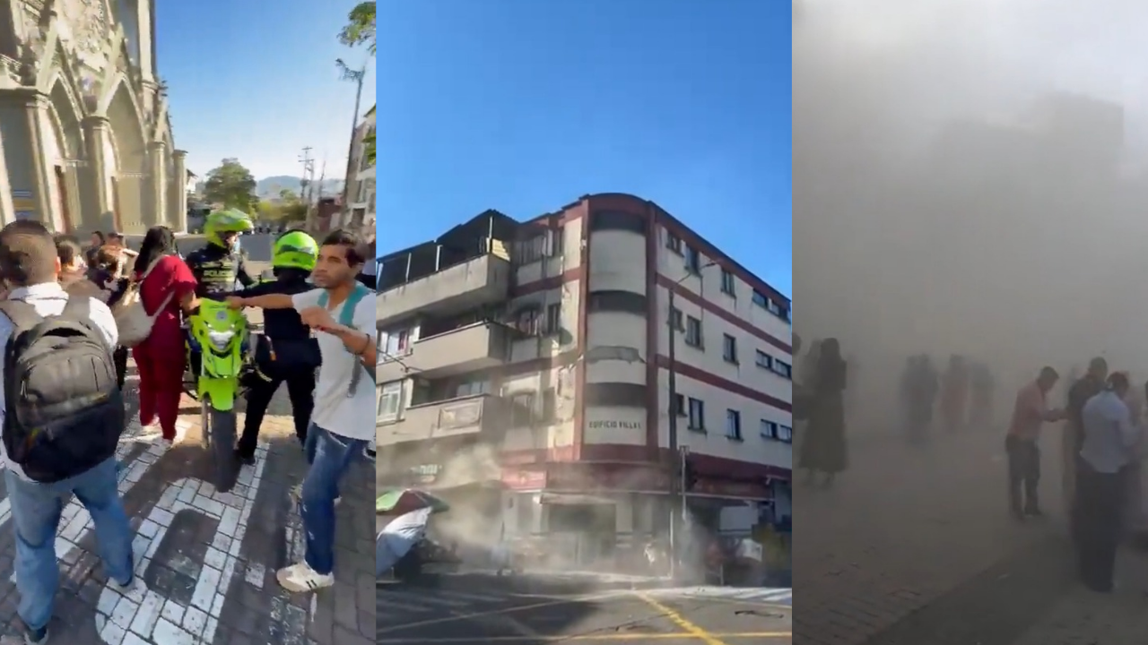
A powerful earthquake struck western Colombia on Monday morning, August 10, sending strong shaking across a large part of the country and causing structural damage in several major cities. The epicenter was near San José del Palmar in the department of Chocó, and the earthquake was felt from the western and central regions of Colombia to neighboring countries.
The magnitude reported by international and Colombian authorities has differed. The U.S. Geological Survey (USGS) measured the earthquake at magnitude 7.4, with a depth of about 107 kilometers, while early Colombian reports have placed the magnitude in the 6.6–6.7 range, with depth estimates around 79–96 kilometers. The discrepancy between the measurements remains unresolved, so both figures are being reported.
The earthquake struck at approximately 7:34 a.m. local time, with the USGS placing the epicenter about five kilometers east of San José del Palmar. Despite the considerable depth, the strength and long-range shaking caused damage across multiple urban areas.
Deaths and injuries reported
Initial casualty information changed rapidly as emergency crews began assessing affected communities.
Reuters reported that at least two people had died, with deaths reported in Manizales, while additional people were trapped or injured in damaged structures. The agency reported that the earthquake caused widespread destruction and that authorities were continuing rescue operations.
The situation remains fluid, and casualty figures could increase as emergency teams reach damaged buildings and isolated areas.
In Quibdó, the capital of Chocó, officials reported injuries and serious building damage. Authorities also warned residents about the possibility of aftershocks.
Damage reported in Manizales
Manizales, in the department of Caldas, was among the cities that experienced significant effects.
One of the most prominent structures affected was the Metropolitan Cathedral Basilica of Our Lady of the Rosary, a historic landmark in the city's center. Reports indicate that part of the cathedral structure was damaged, including a section of its tower. AP reported that part of a cathedral tower collapsed during the earthquake.
The cathedral is one of Manizales' most important architectural and cultural landmarks. It was constructed between 1928 and 1939 and has previously been affected by major earthquakes, including the devastating 1962 earthquake. Historical records note that the structure has undergone restoration following earlier seismic events.
Because reports and images from the scene were still developing, claims that the cathedral's entire dome had collapsed should be treated cautiously unless confirmed by local authorities.
Buildings damaged in Cali
The earthquake also caused substantial damage in Cali, one of Colombia's largest cities.
Emergency authorities reported damaged buildings, including structures that lost portions of their roofs and other parts of their construction. Later reports indicated that numerous structures were damaged and that people were trapped in some buildings. Reuters reported that around 20 structures had collapsed in Cali, prompting local authorities to request additional rescue assistance from Bogotá and Medellín.
AP separately reported that at least 19 buildings were damaged in Cali, with occupants trapped in some locations. The slightly different figures reflect the fact that authorities were still conducting inspections and compiling information.
Emergency crews moved through affected areas looking for people who might have been trapped beneath rubble, while officials assessed whether damaged structures remained safe to enter.
Pereira also reports major structural damage
Pereira, another major city in Colombia's coffee region, was also significantly affected.
Reports indicated structural damage across the city, with emergency authorities inspecting buildings and infrastructure. The earthquake also disrupted operations at several airports, including airports serving Pereira, Manizales and Armenia, as authorities checked facilities for possible damage before normal operations could resume.
The extent of the damage in Pereira was still being assessed as emergency operations continued.
Shaking felt across Colombia
The earthquake was felt over an exceptionally wide area.
- Strong shaking was reported in:
- Cali
- Medellín
- Manizales
- Pereira
- Armenia
- Ibagué
- Bogotá
- Quibdó
Other cities and municipalities across western and central Colombia
Residents in Bogotá reported feeling the earthquake strongly enough to evacuate buildings as a precaution. Bogotá Mayor Carlos Galán initially said there were no reported injuries or significant structural damage in the capital, although inspections continued.
The earthquake was also felt outside Colombia, including parts of Ecuador, Panama and Venezuela, demonstrating the unusually broad reach of the seismic waves.
Why was the earthquake felt so widely?
One important factor was the earthquake's depth.
The USGS estimated the earthquake at approximately 107 kilometers below the surface. Colombian estimates put the depth somewhat shallower, around 79–96 kilometers. Either way, this was not a shallow earthquake.
Deep earthquakes can behave differently from shallow earthquakes. Although greater depth generally reduces some of the destructive effects that occur immediately above a shallow epicenter, strong seismic energy can travel over a very large area. With a powerful earthquake of magnitude 7 or greater, that means communities hundreds of kilometers away can experience noticeable or even strong shaking.
This helps explain why people in cities far from San José del Palmar reported the earthquake.
The combination of magnitude, depth, local ground conditions and the vulnerability of individual buildings determines how much damage ultimately occurs.
Colombia's location makes earthquakes a persistent threat
Colombia is located in a complex tectonic region where several major plates interact.
The country lies near the boundaries and influence of the Nazca, South American and Caribbean plates, making parts of Colombia particularly vulnerable to earthquakes.
The western portion of the country has experienced numerous significant seismic events throughout history. The coffee-growing region in particular has suffered major earthquakes, including the devastating 1999 Armenia earthquake, which caused extensive destruction and loss of life.
The location of the August 10 earthquake near San José del Palmar is therefore significant because it occurred within a region with substantial seismic activity.
No tsunami threat reported
Despite the earthquake's western Colombian location and its proximity to the Pacific region, authorities did not issue a tsunami warning following the event. Reports indicated that the earthquake's considerable depth and inland epicentral location did not produce conditions that warranted a tsunami alert.
Authorities nevertheless remained alert for aftershocks and continued inspecting buildings and infrastructure.
Emergency response underway
Colombian authorities activated emergency response mechanisms as reports of damage emerged from multiple departments.
Rescue workers, firefighters, police and local emergency teams were deployed to inspect damaged structures and search for people who may have been trapped.
The scale of the earthquake meant that response operations had to take place simultaneously across several cities. In Cali, additional rescue support was requested from other major cities because of the number of damaged structures.
Authorities also began inspecting airports, roads, public buildings and other critical infrastructure.
Residents in affected areas were urged to remain cautious because damaged buildings can become unstable after the initial earthquake, particularly if aftershocks occur.
Casualty and damage figures remain preliminary
Because the earthquake occurred only hours before the latest reports, the casualty and damage figures remain subject to change.
Early reports from different agencies have already produced different numbers for both structural damage and the earthquake's magnitude. This is normal during the first stages of a major disaster, when authorities are still gathering information from multiple locations.
For this reason, reports should distinguish between confirmed information and preliminary claims.
As of the latest available reporting, the USGS magnitude is 7.4, the epicenter is near San José del Palmar, Chocó, and significant structural damage has been reported in cities including Manizales, Cali, Pereira and Quibdó. At least two deaths have been reported, while rescue and assessment operations continue.
More information is expected as emergency teams complete their inspections and authorities update the number of casualties, damaged buildings and people requiring assistance.
Facts
📍 Epicenter: Near San José del Palmar, Chocó, Colombia
📅 Date: August 10, 2026
⏰ Time: Approximately 7:34 a.m. local time
📏 USGS magnitude: 7.4
📊 Colombian estimates: Approximately 6.6–6.7
🌍 USGS depth: About 107 km
🏚️ Major impacts: Manizales, Cali, Pereira, Quibdó and other areas
🕯️ Reported deaths: At least 2, according to the latest Reuters report
🚑 Response: Rescue and structural assessments ongoing
🌊 Tsunami: No tsunami threat reported
FlashNews24 will continue updating this story as Colombian authorities release verified information on casualties, structural damage and possible aftershocks.

About the Author
Harish Kumar is the founder of FlashNews24 and covers world news, technology, science, and weather developments.